Cyclone Road 
CHASE BLOG
Cyclone Road |
CHASE BLOG |
|
Blog Front Main Chase Page All Chase Reports YouTube Site Feed  
Amos Magliocco's Storm Chase Blog
|
Wednesday, May 26, 2010
Posted
10:47 AM
by Amos Magliocco
I'll start the updates tonight, one chase day at a time. Speaking of photography from recent chases, check out the amazing images from my friend Dr. Bill Hark, especially this image: http://www.harkphoto.com/052410tornadochurch.jpg And Bill's full album from the same chase day is here: http://www.harkphoto.com/05242010.html My own meager exposures coming soon! Thursday, May 20, 2010
Posted
12:55 PM
by Amos Magliocco
Scott and I departed Amarillo and elected to follow the boundary/frontal zone ahead of the confluence. North out of Clinton with Derek Deroche, we turned west on 47 (south of Putnam) which brought us to SR34 (the Leedey road). A few more miles north, a narrow funnel came into view on the southern tip of the updraft base, an unexpected sight. The longer it held together the clearer this was rotating and stretching toward the ground. It was difficult to find a location to shoot the tornado without surface obstruction, thus I’m jealous of the excellent image Dan Cook posted on Stormtrack from his Sirvakta/COD intercept. Scott and Derek found a fair vantage point and climbed up on their car roofs to shoot and I settled for the best spot I could find. I was too picky and missed the best moments of this rapid tube. Unlike the next tornadoes the circulation was quite clean and rain free as the storm was still young.  Behind us a big problem presented itself: the Canadian freaking River. Another lowering seemed to blink in and out of the rain to the north so we pursued, but when that feature wrapped up and tucked itself away, we started evaluating our bad options. Derek and Scott went east a few clicks and I turned back south to begin the inevitable, horribly time consuming flanking action that took me: (1) around Aledo, (2) past Putnam, (3) through Thomas, and (4) wide of Watonga (alright, that was a stretch) until I finally turned north again toward Loyal. Three miles or so up CR N2740, I noticed a rapidly rotating area tucked northwest of the core where condensation tendrils touched the ground intermittently. This circulation rushed toward my east road at Loyal and so my photo is taken under duress.  At Loyal, I dashed ahead of the tornado several miles and turned to watch. Here’s where all the precip in and around the hook region was unhelpful. I may have seen a tall stovepipe in the rain, but far more obvious moments later was a large tornado south of the road. This big, blocky wall cloud was lightly-shrouded in rain but quite visible and decently contrasted. I’d place this at approximately the intersection of E0740 Rd and N2800.   It widened considerably before I lost sight of it in the rain. In the river valley immediately west of Dover, trying to maintain my position north (probably northwest) of the tornado, I encountered an inflow jet which yanked large branches across the road in mid air. In no mood for impalement I bolted north into the core. A long flank through the heavy rain and golfball hail (horde free!) and then back south on the interstate yielded a glimpse of a bowl-lowering east of Guthrie, right over the chaser-congested SR 152. I was still north of the circulation, north of Guthrie by four miles on I-35, yet with a clear vantage point. After that feature slipped away my chase was over. Our entire group, including Bob Fritchie, Rachel Sigler, Katie Burtis, Jason Levit, and Laruen Hill, stopped in Edmund at the Olive Garden.
Posted
12:53 PM
by Amos Magliocco
Scott Blair and I met at Nara Visa, NM hoping our target storm would fire on the DL to the west. However the confluence zone along the wind shift initiated practically over our heads and developed into the storm we chased all day. We made a long flanking maneuver through Dalhart south to Dumas. On SR 87 west of Dumas, we saw a brief tornado, so rapid that I couldn’t get my camera in time.. Then, east of Dumas another, larger tornado formed, though in much rain as was the theme for the whole day (and much of the next).  The last tornado, my favorite of the two day event, was two miles northwest of Stinnett on the forward flank of a deeply grooved and stunning HP / wet classic hybrid. Shooting wide open with my 10-22mm, I noticed a needle form in the bottom of the frame. At first I ignored it since a tornado was the last thing I expected to see. But it grew into a nice laminar cone, touched down, and spun about five minutes. Just beautiful. This was a real treat since we’d gone north at Stinnett strictly for the structure view, which was stunning in its own right. 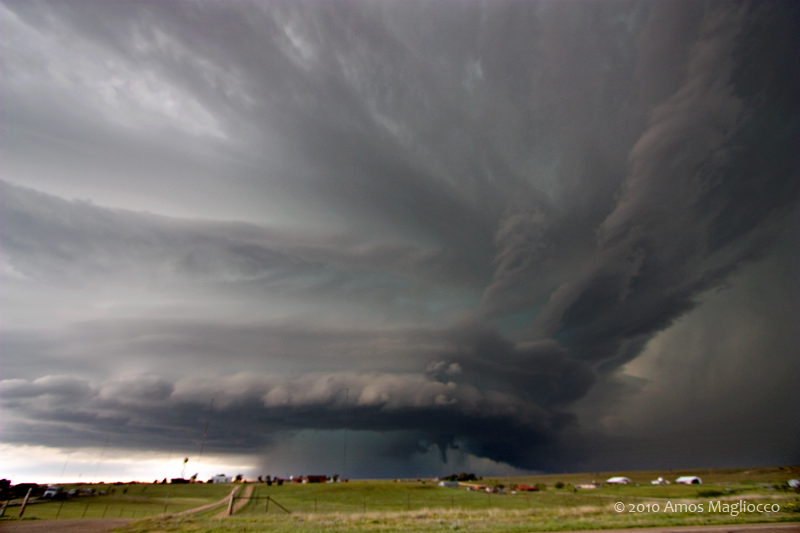  Roads east of Stinnett don’t exist, as we unhappily rediscovered, so rather than another massive flanking maneuver from some 19th century infantry manual, we ate steak in Amarillo with Alnado and others. Saturday, May 15, 2010
Posted
12:55 PM
by Amos Magliocco
On Andrew Marsteller's first storm chase we observed three tornadoes near Wakita, Oklahoma between 3:30 PM CT and 4:15. We met up with Dave Fick and his friend Jeneane, as well as Scott Currens, and intercepted the storm on State Road 11 in northern Oklahoma, not far from Wakita, where the movie Twister was filmed. The meso was probably two miles west of our location when the inflow increased substantially, making it difficult to hold cameras and camcorders still and threatening to overturn tripods. The first indication of a tornado was a brief funnel that looped and twisted then disappeared before reforming again to the northeast near the roadway. The entire cell turned right and moved due east, coming directly down the road toward our location as the large mesocylone rotated impressively. Several more condensation structures developed out of this--proof of the violent circulation on the ground--and we were convinced a violent wedge tornado was about to appear.  Andrew films the developing tornado outside Wakita, Oklahoma  Scott and I mentioned how we never thought of having a picture taken with a tornado behind us. I'm glad he mentioned it, because these were the only shots of mine that turned out.  I thought that with all the traffic on this small road, and a dramatic storm motion over fifty knots, it was wise to leave sooner rather than later, so Andrew and I repositioned eastward before the chaser congestion caused several vehicles to be struck by tornadoes, including a tour group bus which lost all the glass and left several customers bloodied and terrified. We caught glimpse of a third tornado to our west northwest, a long elephant trunk in the rain, but never had an opportunity to shoot it. We saw what others have described as a wedge, but with so much rain to our north northwest (at the time) I can't say definitively that I saw this. With the rocket speed of the storm, flanking it again was hopeless. We hurried to Interstate 35 and dropped south, thinking we could barrel through the core of the "Red Rock" storm and perhaps get in front of cells then moving through the OKC metro area. This was always a foolish notion, and when the core of the Red Rock storm began dropping golfballs on the highway we stopped. Good thing, too, since baseballs were deeper in the core and several chasers lost glass as a result. The hail was still intact when we reached the swath.  For whatever reason, we turned east on 412 and drove all the way to Tulsa. I think we were attempting to flank something, but it was absurd and only yielded a decent steak at Texas Roadhouse, to celebrate the day's haul and Andrew's first tornado. This is all tempered by the loss of life and property in the Oklahoma City metropolitan area obviously. That aspect is one that no storm chaser anticipates or enjoys. Fortunately for most, the warning system in Oklahoma, from the SPC to NWS to local media, along with stormchasers and volunteer spotters, performed brilliantly and the loss of life was remarkably low considering the power and path of the storms.
|