Cyclone Road 
CHASE BLOG
Cyclone Road |
CHASE BLOG |
|
Blog Front Main Chase Page All Chase Reports YouTube Site Feed  
Amos Magliocco's Storm Chase Blog
|
Saturday, May 30, 2009
Posted
5:58 PM
by Amos Magliocco
"For many years I was self-appointed inspector of snow-storms and rain-storms, and did my duty faithfully; surveyor, if not of highways, then of forest paths and all across-lot routes, keeping them open, and ravines bridged and passable at all seasons, where the public heel had testified to their utility." Saturday, May 16, 2009
Posted
11:07 PM
by Amos Magliocco
Friday, May 15, 2009
Posted
12:35 PM
by Amos Magliocco
 It's so strange to be sitting here in May with no chase planned on a legit chase day like today, because I had to administer a final and close on my house, and no chases planned in the foreseeable future. On May 15. Unreal. I can only hope the last week of May and the first week of June offer me something in range. Thursday, May 14, 2009
Posted
10:15 PM
by Amos Magliocco
Wednesday, May 13, 2009
Posted
1:29 PM
by Amos Magliocco
But not everybody does. What's much more interesting than the relocation question is the sub-debate about whether VORTEX2 is even a worthwhile project. Some suggest that the original, landmark Project VORTEX didn't have much impact. Wow. This is what I posted to Stormtrack: Another way to see how VORTEX changed operational meteorology would be to study the SELS/SPC Outlook forecast discussions through the years, especially from '96 until today. In the fourteen years I've been reading those products, the incorporation of material regarding boundaries, SRH, low level shear, and a myriad of other concepts has been obvious in both the diagnostic and prognostic portions of those outlooks. The old products are available to peruse without much trouble. If you want to see where the rubber meets the road, that's one place to find it. If you've learned anything about forecasting severe storms and tornadoes from reading the Day 1 or Day 2 outlooks, then you've benefitted directly from the original VORTEX. Monday, May 11, 2009
My guess is that the cap won't break tomorrow. If the target area were closer I'd go test that idea in person, but from this distance and with papers to grade, I can't do it. Amazing environment if something pops, however.
Saturday, May 09, 2009
Posted
1:27 AM
by Amos Magliocco
 May 1, 2009. 5:11pm CT. May 1, 2009. 5:11pm CT.
Friday, May 08, 2009
Posted
11:26 PM
by Amos Magliocco
On the 5th, I started in Olney where I was joined by Scott Eubanks. I wanted to stay up on the warm side of the front and out of the high temps to the south, believing that we needed some boundary magic for any hope of a tornado and aware that I was already on the southern periphery of supportive winds aloft. Of course the best storm fired south of me near Breckenridge. The intial cell died and second formed practically over the city. We tried to make the turn south just ahead of the meso but elected to return east instead and take the next south option, where of course the bridge was out. We continued east to 16 as the storm grew in intensity and areal coverage and began its infamous hail bombings of unsuspecting chasers. At last we flanked it and beat the meso to Strawn, where we found ourselves between the wall cloud and the damaging hail core, which was at this point pounding vehicles on I-20 with baseballs and softballs. At the intersection of I-20 and SR 16, Glenn Dixon joined us as the the storm produced one of its many impressive wall clouds, complete with rotation, clear slot, tail cloud, and everything but tornado. From Strawn to Desdemona to Stephenville, the storm pushed toward the instability axis and into practically still and tropical upper level conditions.  At the intersection of Interstate 20 and State Road 16, south of Strawn, Texas. May 5, 2009. 8:08pm CT. As night wore on the updraft twisted and tilted over, exposing the starry sky and moon in the background. Structurally it was a treat after a mostly mediocre daylight performance. 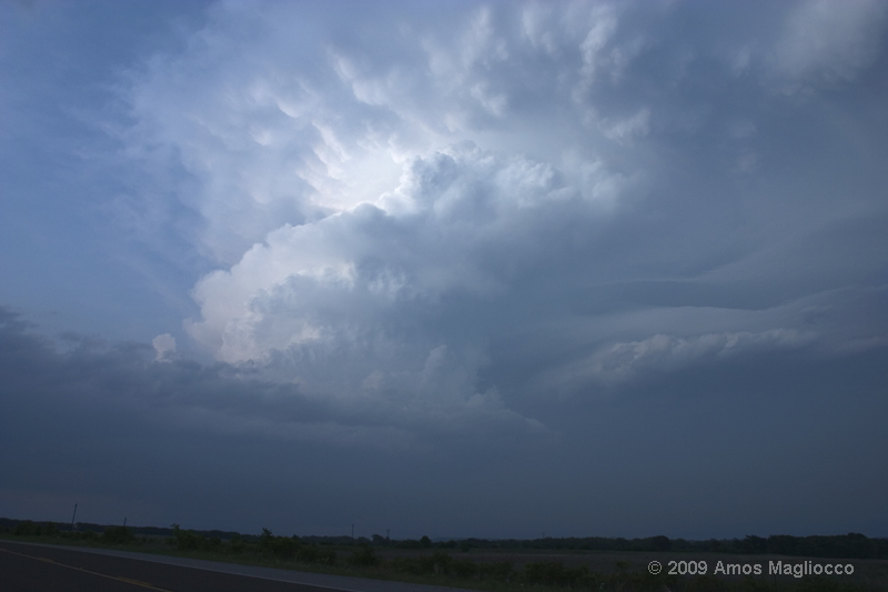 May 5, 2009. 8:34pm CT. Now take that same setup and move it 200 miles north, to northwest of Ardmore, Oklahoma. On Friday May 8, I spent a few hours in the Ardmore Starbucks working on a writing project and monitoring radar and satellite. I've done this before and actually make a lot of progress there since I don't know a soul and there's nothing much happening outside. My first storm fired west of Springer near Graham. On Poolville Road I drove right to the updraft base and observed how quickly the low level features were organizing. I hoped I could cheat an Umscheid/Knox City style tornado out of the storm despite its immaturity. I've seen this happen in the right low level CAPE and shear environments, almost always on a boundary. And it nearly looked like it would.  Scott Eubanks shooting an early wall cloud near Graham, Oklahoma. May 8, 2009. 7:22pm CT. Rapidly the storm strengthened and turned right, rolling south toward me. Since I was on an utterly abandoned road and didn't want to turn my back on the wall cloud to reposition, I drove backwards a while. I only escaped legal consequences for this "hyena-is crime" because of my secret chaser associations and political favoritism, or else the cows would have turned me in for sure. Scott Eubanks made the same road choices (though he did not chase backwards as far as I know) and found me as I was retreating southward in advance of the cell. We spent another hour scavenging for unobstructed views of the various promising wall clouds before a second storm to the south contaminated our inflow. We never saw another organized lowering again. We raced south to catch the Red River storm, but wound up eating Paprika Schnitzel and German sausage in Muenster instead. Wednesday, May 06, 2009
If my '09 chase season thus far were a stock, I'd dump it. Sell sell sell.
Tuesday, May 05, 2009
Posted
12:49 PM
by Amos Magliocco
"Like anyone could even know that!" -Napoleon Dynamite Monday, May 04, 2009
This time I'm going to hang out by the lake, and I'll probably bring some work to do while we whittle away the CIN.
The 12z WRF is complicating my life. Now Thursday looks like a chase day, too.
Sunday, May 03, 2009
I'll say this much: whatever my target on Tuesday, I'll go fifty miles west of it. I've been too far east too many times this season.
Posted
12:04 PM
by Amos Magliocco
On May 1, I targeted the eastern shore of Lake Kemp, north of Seymour, because I wanted water in the foreground. Storms fired well to the southwest, however, and I couldn't resist. With Dave Fick, Scott Eubanks, and Brian Fant (back in the game after several years; welcome back, Brian!), I rolled toward Munday, Texas. Unfortunately, we arrived moments after Mike Umscheid saw his tornado near Knox City. We dropped south at Munday, west at Weinert, and south again on the unexpectedly-paved Ranch Road 2163. The storm presented several wall clouds but each was undercut by cool, dry RFD, despite the high theta-e inflow. Storm motion was due south and with every degree of southern latitude we lost midlevel wind strength. These storms were poorly ventilated and probably within an area of weak midlevel lapse rates. I never observed the severe hail one would expect with ~4000 j/kg SBCAPE. Eventually I reached SR 6 and followed it south to Stamford. The storm continuously produced new wall clouds with weak rotation, and near Stamford there was a ground circulation beneath one of these wall clouds. I saw the circulation in the field in front of me and I jumped back in the car. I was reminded of the stout little circulation that caught Mike Hollingshead and I by surprise several years ago and damaged Mike's open door (and filled his Mustang with dirt). I shot several stills of this feature which I haven't reviewed yet. At the time, I would have called it a gustnado, but chasers whose opinions I respect, like my old friend Shane Adams, say otherwise and have more compelling imagery than I do. If Shane says it's a tornado that's usually good enough for me. I need to examine my photos again. Eventually this storm weakened and we raced back north for a new storm near Seymour. We reached it in time to witness a disappearing act, convection literally evolving from a small storm to a cloud to clear air in 20 minutes flat. We met up with Australian chaser Daniel Shaw, a cool guy who entertained us with stories of chasing down under, and, with Michigan chasers Kurt Hulst and Nick Grillo, we all returned to Seymour for dinner at the Mavericks Cafe. Good times. Yesterday, May 2, Kurt, Nick, and I chased around North Texas, always a prodigious waste of time. In a tropical airmass with modest shear and slackened surface features, we darted from embedded storm to embedded storm. Other than the gridlocked traffic near the Texas Motor Speedway, we had a pretty good time, but the storms simply couldn't maintain their structures in so much rain and cold outflow. Too much convection. Looks like a few down days perhaps and at just the right time for me. Pictures later this week.
|